The Town of Renshaw
Created by Sydney Whitaker on Sat Sep 12th, 2026 @ 7:19pm
Renshaw: Districts and Local Geography
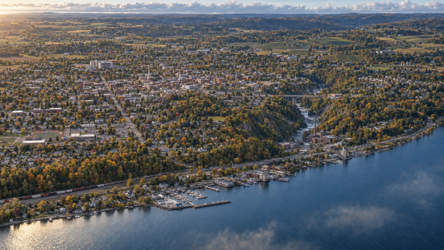
Renshaw’s districts are distinct without resembling separate towns. The municipality remains small enough that most residents pass through several of them during an ordinary day, but Alder Creek, the surrounding hills, the gorge and intervening stretches of farmland have created strong local identities.
Municipal structure
Legally, the community is the Town of Renshaw. Its central settlement is an unincorporated hamlet also called Renshaw rather than a separately governed village. The Renshaw Police Department therefore serves the central settlement, the Landing and the surrounding rural territory as one municipality. The Ontario County Sheriff possesses concurrent countywide authority and can assist within Renshaw, but does not command or automatically supersede the town police.
Old Renshaw
Location and layout
Old Renshaw is the compact historic centre of the town, occupying the higher ground immediately north of Alder Creek. Main Street runs east to west through the district and is crossed by Market Street near the civic centre.
Most of its buildings are two or three storeys high, with brick shopfronts at street level and offices or flats above. Town Hall, the police station, library, post office and town justice court all stand within several blocks of one another. Independent shops, a pharmacy, several bars and restaurants and a stubbornly surviving department store share the centre with enough empty premises to keep it from feeling artificially prosperous.
Civic centre and police station
The police station stands near the western end of downtown, behind Town Hall. It is functional rather than picturesque, with its public entrance facing the civic square and its secured vehicle yard opening onto a rear street. The position keeps the department physically embedded in everyday town life.
Residents normally call this district downtown. The name Old Renshaw is used when distinguishing its historic streets from the wider town.
North Hill
Character and residents
North Hill rises behind downtown and contains many of Renshaw’s grander nineteenth- and early-twentieth-century houses. Mature trees, stone walls and steep residential streets give the district a quieter, more sheltered atmosphere.
Some of Renshaw’s oldest families remain here, although they now share the Hill with doctors, lawyers, winery owners, university commuters and people who purchased neglected houses before prices began to rise. The district is affluent without being uniformly wealthy; a number of its larger homes have been divided into flats or allowed to deteriorate behind impressive façades.
Landmarks and influence
Renshaw’s small regional hospital stands near the crest of the hill, where the site provides room for later extensions. An older cemetery occupies the eastern shoulder, overlooking Alder Glen without intruding upon it.
North Hill possesses influence disproportionate to its population. Decisions made over private dinners there have a habit of reaching Town Hall before they reach the public.
Southbank
Location and community
Southbank begins across the two principal bridges over Alder Creek. It is Renshaw’s largest residential district and contains a mixture of older mill-worker houses, modest detached homes, duplexes and post-war estates.
The central school campus, recreation grounds, primary fire station and a practical strip of supermarkets and everyday businesses are all located here. Southbank is younger, busier and less carefully preserved than Old Renshaw. Many of the town’s police officers, teachers, tradespeople and hospital staff can reasonably afford to live somewhere within it.
Landscape and local tensions
The lowest streets beside Alder Creek occasionally flood, while the outer neighbourhoods gradually rise towards open farmland. Southbank is not Renshaw’s “bad area”, although some North Hill residents speak about it as though it were.
Its resentment is quieter and more practical: residents have watched public money beautify downtown and the Landing while Southbank’s roads, drainage and schools are repeatedly told to wait.
The Mill Quarter
Industrial landscape
The Mill Quarter occupies both banks of Alder Creek downstream from Old Renshaw, ending where the valley narrows into Alder Glen. Older residents still call it the Mills; the name Mill Quarter originated with a redevelopment scheme and was adopted enthusiastically by estate agents.
Its surviving buildings include the original stone mill, several red-brick factories, an old foundry, warehouses, municipal maintenance yards and the remains of the disused railway spur. Some have become flats, studios, workshops, restaurants and a brewery. Others remain boarded up or are used for storage with little oversight.
The millrace and redevelopment
The old millrace still runs beneath portions of the district. It has been redirected, covered and rebuilt so many times that surviving municipal plans do not agree on its precise course. Forgotten chambers, blocked channels and concealed access points remain beneath the streets without requiring an implausible network of natural caverns.
The Quarter is Renshaw at its most transitional: attractive by daylight, unevenly lit at night and full of arguments over who redevelopment is actually intended to benefit.
West Ridge
Rural Renshaw
West Ridge begins beyond NY 14A and contains most of the municipality’s working countryside. Its landscape is a mixture of orchards, dairy farms, vineyards, headwater wetlands, wooded ravines and newer houses built upon subdivided farmland.
Families who have worked the area for generations live beside wealthy newcomers seeking privacy and seasonal visitors who underestimate its winter roads. Old Quarry Road climbs through the southern woodland before becoming narrower and increasingly poorly maintained near the town boundary.
The quarry and field residence
The former quarry is a shallow shale working, partly flooded and fenced off with varying degrees of success. Beyond it, outside Renshaw proper, stands the secluded property acquired by the specialised unit. The property remains approximately fifteen minutes from the police station but cannot be seen from Route 14A.
West Ridge produces comparatively few routine police calls. Those it does produce often involve long response distances, farm machinery, isolated homes, hunting land, missing walkers or roads made impassable by weather.
Renshaw Landing
Lakefront settlement
Renshaw Landing lies at the mouth of Alder Creek, physically separated from the main town by Alder Glen and several miles of vineyard slopes. Route 14 and the active freight railway pass through the settlement before the land reaches Seneca Lake.
The older section contains narrow streets, weathered houses, former warehouses, an old cannery and buildings once associated with railway and lake freight. The public harbour, boat launch, marina and lakeside park occupy the northern side of the creek. Cottages and expensive converted properties extend along the shore, while most year-round residents remain concentrated around the old commercial streets.
Seasonal life and local identity
The Landing’s permanent population is only around one thousand, but it grows considerably during summer and harvest season. This creates two different communities occupying the same space: residents who remember when the waterfront was industrial and seasonal owners who believe they discovered it.
People say they are going down to the Landing, both because it lies east of the central settlement and because the lakeside stands more than two hundred feet below upland Renshaw.
Alder Glen
Gorge and natural boundary
Alder Glen is not formally a district. It is the wooded separation between the Mill Quarter and Renshaw Landing, containing Mill Falls, the gorge trail, the abandoned mill railway spur and the high bridge carrying Landing Road.
Parts of the Glen form a municipal preserve, while other parcels remain privately owned or disputed. The principal trail is maintained and popular; the old railway grade and lower creek paths are not. Despite lying only minutes from homes in either direction, the depth of the gorge and density of the woodland can make it feel remarkably isolated.
The Wider Landscape
Seneca and Haudenosaunee presence
There is no separate “Indigenous district” within Renshaw. Seneca and wider Haudenosaunee history belongs to the entire landscape rather than being confined to one picturesque corner of it, and present-day Indigenous residents may live, work and participate in every part of the town.
Geographical progression
West Ridge → Southbank and Old Renshaw → the Mill Quarter → Alder Glen → Renshaw Landing and Seneca Lake.
Categories: Town and Recurring Locations